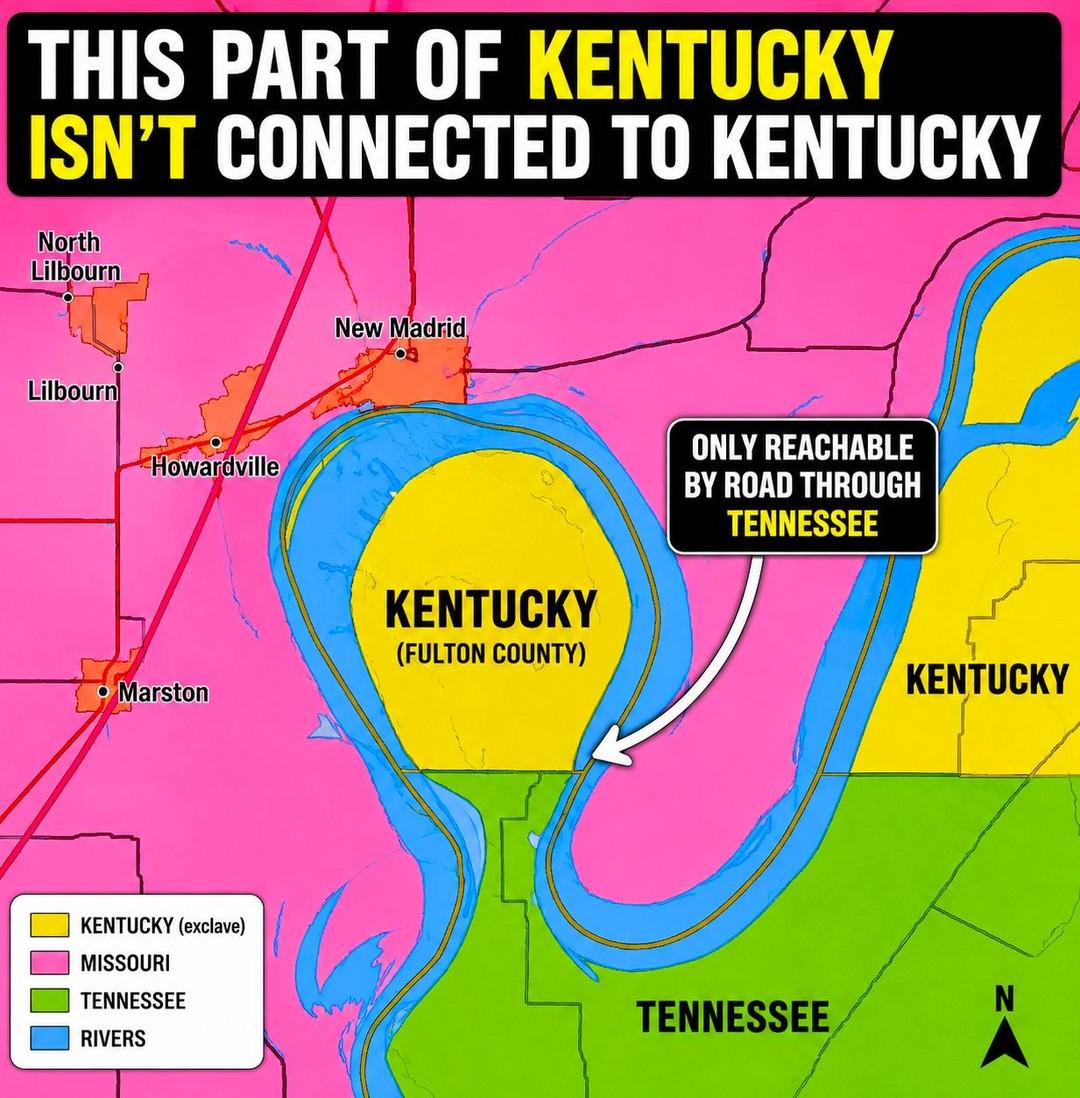
To drive to this part of Kentucky, you have to go through Tennessee. There is no direct road connection to the rest of Kentucky.
The Kentucky Bend exists because the Mississippi River shifted course around a massive river meander after the border had already been defined. The situation became even stranger after the huge New Madrid earthquakes of 1811–1812, which dramatically altered parts of the river system in the region.
OneMisterSir101 on
Case of one border being defined by latitude and one being defined by a river.
Prometheus_Bobert on
It apparently has a total population of 9 as of 2020
griffmanr on
The Northwest Angle would like a word
Technoir1999 on
Did Kentucky and Tennessee give consent to this Missouri penetration?
You guys don’t know about that part of Washington State only accessible through Canada, I imagine
LomentMomentum on
Obviously state boundaries followed the River at the time they became states, not as they appear now.
Parking_War_4100 on
Who if any, polices this area?
BlackshirtDefense on
Welcome to the traveling Mississippi, Missouri, and oxbow lakes.
MileHigh_FlyGuy on
This section doesn’t even matter because it’s just some fields. The section of Iowa (Carter Lake) in Nebraska (Omaha) actually matters because it has tons of houses and industry and is the major connection to the Airport.
littlehound on
Been there twice. There is a Kentucky historical marker there noting background of the area. Desolate, flat, and eerie.
FormerCollegeDJ on
Angle Inlet, MN would like a word with you.
Blaizefed on
I live very close to a similar situation in New Jersey. We are right on the NY border and there is a small cul de sac that has 5 houses on one side of the road in NY, and the houses on the other side are in NJ. Only accessible thru NJ.
SonofaBridge on
Point Roberts in Washington wins weirdest border. It’s only attached to Canada, far from the US, and doesn’t even have a ferry service.
TAsCashSlaps on
There’s a couple of these along the Mississippi River. I went to a farm that was technically in TN, but we had to cross over into Arkansas to actually reach it
g_rich on
Wouldn’t this also technically be reachable by boat by either Tennessee or Missouri waterways?
Goingboldlyalone on
Well you know, “we gotta save some for those guys over there..”
bagsofcandy on
But why!?!
IoIoIoYoIoIoI on
Point Roberts only reachable by road from British Columbia, not from Washington State.
EekleBerry on
In the future this might resolve itself as the neck will be eroded away from the river.
localistand on
This area was scene of a major earthquake event during a time (1811-1812) in which it was scarcely populated. Eyewitness account said the Mississippi ran backwards for a time from the shocks. ‘General ground warping, ejections, fissuring, severe landslides, and soil liquefication’ were some effects that sound pretty terrifying.
Just to the southeast of this mapped area is Reelfoot Lake, which was formed from the topographical effects of the New Madrid earthquake.
OrchidFluid2103 on
It’s called an “exclave”, as stated in the legend, which is nothing special, at least not special enough for r/MapPorn.
What is “special” in another way however is that someone decided to create a map of states and give them a unique color (ok), then somehow decided to give the river a separate color (weird and not ok, since they also belong to one of the states, most likely divided somewhere in the middle), and then, for some reason, decided to also place polygons of cities on top of that (definitely not ok), and then label the states in the map as well as in the legend (psychopath design) and then, after all of that, added the ACTUAL BORDER between the states, which obviously goes through the river, and decided that the color of kentucky would be the best fit for the entire line.
This really is a one of the worst maps I have ever seen, only topped by some kind of speech bubble, which apparently points out that the in the middle of the river between the exclave and Missouri can only be reached by a road through tennessee. But hey, at least it got an absolutely useless and comically oversized north arrow. Technically, the legend is not only bad it’s also plain wrong, as the yellow area to the right is “Kentucky”, and not “Kentucky (exclave)”
What a great submission to r/MapPorn
funkycat75 on
We (Kentucky) are taking over the rest of the US a few acres at a time. One day you look out your window and BOOM, Kentucky. If you see a thoroughbred drinking bourbon and dribbling a basketball, it’s already too late.


25 Comments
To drive to this part of Kentucky, you have to go through Tennessee. There is no direct road connection to the rest of Kentucky.
The Kentucky Bend exists because the Mississippi River shifted course around a massive river meander after the border had already been defined. The situation became even stranger after the huge New Madrid earthquakes of 1811–1812, which dramatically altered parts of the river system in the region.
Case of one border being defined by latitude and one being defined by a river.
It apparently has a total population of 9 as of 2020
The Northwest Angle would like a word
Did Kentucky and Tennessee give consent to this Missouri penetration?
Check out [Point Roberts](https://en.wikipedia.org/wiki/Point_Roberts,_Washington), a peninsula in America only accessible by land through Canada.
In like ten years, it will be a island
You guys don’t know about that part of Washington State only accessible through Canada, I imagine
Obviously state boundaries followed the River at the time they became states, not as they appear now.
Who if any, polices this area?
Welcome to the traveling Mississippi, Missouri, and oxbow lakes.
This section doesn’t even matter because it’s just some fields. The section of Iowa (Carter Lake) in Nebraska (Omaha) actually matters because it has tons of houses and industry and is the major connection to the Airport.
Been there twice. There is a Kentucky historical marker there noting background of the area. Desolate, flat, and eerie.
Angle Inlet, MN would like a word with you.
I live very close to a similar situation in New Jersey. We are right on the NY border and there is a small cul de sac that has 5 houses on one side of the road in NY, and the houses on the other side are in NJ. Only accessible thru NJ.
Point Roberts in Washington wins weirdest border. It’s only attached to Canada, far from the US, and doesn’t even have a ferry service.
There’s a couple of these along the Mississippi River. I went to a farm that was technically in TN, but we had to cross over into Arkansas to actually reach it
Wouldn’t this also technically be reachable by boat by either Tennessee or Missouri waterways?
Well you know, “we gotta save some for those guys over there..”
But why!?!
Point Roberts only reachable by road from British Columbia, not from Washington State.
In the future this might resolve itself as the neck will be eroded away from the river.
This area was scene of a major earthquake event during a time (1811-1812) in which it was scarcely populated. Eyewitness account said the Mississippi ran backwards for a time from the shocks. ‘General ground warping, ejections, fissuring, severe landslides, and soil liquefication’ were some effects that sound pretty terrifying.
https://en.wikipedia.org/wiki/1811%E2%80%931812_New_Madrid_earthquakes
Just to the southeast of this mapped area is Reelfoot Lake, which was formed from the topographical effects of the New Madrid earthquake.
It’s called an “exclave”, as stated in the legend, which is nothing special, at least not special enough for r/MapPorn.
What is “special” in another way however is that someone decided to create a map of states and give them a unique color (ok), then somehow decided to give the river a separate color (weird and not ok, since they also belong to one of the states, most likely divided somewhere in the middle), and then, for some reason, decided to also place polygons of cities on top of that (definitely not ok), and then label the states in the map as well as in the legend (psychopath design) and then, after all of that, added the ACTUAL BORDER between the states, which obviously goes through the river, and decided that the color of kentucky would be the best fit for the entire line.
This really is a one of the worst maps I have ever seen, only topped by some kind of speech bubble, which apparently points out that the in the middle of the river between the exclave and Missouri can only be reached by a road through tennessee. But hey, at least it got an absolutely useless and comically oversized north arrow. Technically, the legend is not only bad it’s also plain wrong, as the yellow area to the right is “Kentucky”, and not “Kentucky (exclave)”
What a great submission to r/MapPorn
We (Kentucky) are taking over the rest of the US a few acres at a time. One day you look out your window and BOOM, Kentucky. If you see a thoroughbred drinking bourbon and dribbling a basketball, it’s already too late.