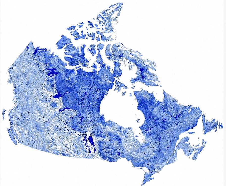
Canada holds more lakes than any other, with over 860,000 large enough to be counted, and roughly a fifth of all the fresh water on Earth sits within its territory. The density of blue across the north traces the basins gouged out by retreating ice-age glaciers, which later filled with meltwater. Much of that concentration lies over the Canadian Shield, the vast bed of ancient rock that underlies the country’s east and centre.
The five Great Lakes alone hold about 18% of the world’s fresh lake water, and Canada shares four of the five with the United States, with only Lake Michigan lying wholly on the American side.
rebelangel004 on
So many waterways, it’s a true nature masterpiece!
rebelangel004 on
Such a beautiful representation of nature!
OperationEpsteinLib on
The humidity if you live on that one side of the country is oppressive in summer and winter.
2PopCans on
Beautiful map, would live to see the great lakes added. Where can I download a high res version?
uncredible_source on
This map really illustrates the western edge of the Canadian Shield where it meets the western canadian sedimentary basin.
DFT22 on
This is SUCH a cool country, in so many ways.
PedalOnBy on
Oh wow, there’s such a clear divide why is that?
ajcain007 on
Incredible how waterways define the nation’s silhouette and ecosystem!
Iunlacht on
Why are the Great Lakes and St-Lawrence not coloured in?
Dizzy-Cartoonist3011 on
And here I am in one of the semi arid parts with sloughs and made reservoirs.
DieHard64 on
This map is a beauty map! Where did the data come from?
Tonight-Own on
Don’t show this to the Don
Cam-Lv on
Aren’t most frozen half the year?
eamondo5150 on
I’m surprised the Fraser River isn’t even prominent.
Considering the havoc it causes on Vancouver area traffic.
IndicationFluffy3954 on
We do be having a lot of water.
BassicNic on
I can see my house from here!
RoyalPeacock19 on
The artist forgot our parts of the Great Lakes
TexasRed-Pew on
Nonsense 😂
FXF_1 on
Now this is MapPorn!
FluffyStormwise on
I think this is fabulous!
Infamous_Thing3887 on
Never new the border with America followed a water way
Username_McUserface on
No one wants to call out how incorrect this AI slop is?
MisterGerry on
Missing Lake Ontario, Lake Huron, Lake Erie and Lake Superior.
LickinThighs2 on
You missed one.
Hypersky75 on

Ok_Hedgehog_8454 on
You’re missing a few big lakes, there, bud
Other-Improvement410 on
As someone lives in an area that shouldn’t be blue

AdditionalSpeaker303 on
There is a line of big lakes, on one side the area is more watery on the other side it is less watery.
All that water is wasted on Canadians, they just don’t understand what they have.
Legitimately 1/5th of the frasier river would be enough to turn the mojave desert into a garden. That is 6 imperial valleys worth of water.
Sucks that it is physically impossible to move that much water.

31 Comments
Canada holds more lakes than any other, with over 860,000 large enough to be counted, and roughly a fifth of all the fresh water on Earth sits within its territory. The density of blue across the north traces the basins gouged out by retreating ice-age glaciers, which later filled with meltwater. Much of that concentration lies over the Canadian Shield, the vast bed of ancient rock that underlies the country’s east and centre.
The five Great Lakes alone hold about 18% of the world’s fresh lake water, and Canada shares four of the five with the United States, with only Lake Michigan lying wholly on the American side.
So many waterways, it’s a true nature masterpiece!
Such a beautiful representation of nature!
The humidity if you live on that one side of the country is oppressive in summer and winter.
Beautiful map, would live to see the great lakes added. Where can I download a high res version?
This map really illustrates the western edge of the Canadian Shield where it meets the western canadian sedimentary basin.
This is SUCH a cool country, in so many ways.
Oh wow, there’s such a clear divide why is that?
Incredible how waterways define the nation’s silhouette and ecosystem!
Why are the Great Lakes and St-Lawrence not coloured in?
And here I am in one of the semi arid parts with sloughs and made reservoirs.
This map is a beauty map! Where did the data come from?
Don’t show this to the Don
Aren’t most frozen half the year?
I’m surprised the Fraser River isn’t even prominent.
Considering the havoc it causes on Vancouver area traffic.
We do be having a lot of water.
I can see my house from here!
The artist forgot our parts of the Great Lakes
Nonsense 😂
Now this is MapPorn!
I think this is fabulous!
Never new the border with America followed a water way
No one wants to call out how incorrect this AI slop is?
Missing Lake Ontario, Lake Huron, Lake Erie and Lake Superior.
You missed one.

You’re missing a few big lakes, there, bud
As someone lives in an area that shouldn’t be blue

There is a line of big lakes, on one side the area is more watery on the other side it is less watery.
All that water is wasted on Canadians, they just don’t understand what they have.
Legitimately 1/5th of the frasier river would be enough to turn the mojave desert into a garden. That is 6 imperial valleys worth of water.
Sucks that it is physically impossible to move that much water.
Where’s Lake Simcoe?
Moist