I’d never would’ve thought that the third option to yes/no will be France
Ragnarotico on
Your map is off according to the data you cited. England and the “Holy Roman Empire” had a higher population than France in 1800 and your map claims otherwise.
Beehous on
A lot of those countries in central and east europe didn’t even exist. a lot of them were mixed between ottoman and austria monarchy.
frolix42 on
This map is incorrect about Russia, which had a population of about 32 – 35 million, more than France (29 – 30 million).
This map is wrong. I see at least one mistake: Russia (No, I don’t support Putin, just tell the truth). I bet, it has other mistakes as well.
Meritania on
The UK had to invent mechanised agriculture because it don’t want France to win anything.
nankainamizuhana on
This is a weirdly convoluted way to say “France was the 4th most populous country in 1800.” You know the phrase, ‘This could’ve been an email’?
smileedude on
“Did France have more people than your country in 1800?”
“FRANCE”
Stiltz85 on
A better question would be “Did your country have a proper census program in 1800?”
Silenc1o on
This makes zero sense as it depicts modern borders, my country (Canada) didn’t exist in 1800 along with many others.
Momosf on
Even if you take the view that a Westphalian-style state is synonymous with our modern usage of the word “country”, your map does not show the extant polities of 1800 with relevant borders.
tswaters on
This would make more sense with a map representing political borders at the time.
chadoxin on
Why are you counting India as one state?
It should be Marathas, Sikhs etc separately.
Maybe one or two of them had more people but not all
portalscience on
/r/dataisbeautiful
Rule 1:
A post must be (or contain) a qualifying data visualization.
From qualifying data visualization rules:
***In addition, binary TRUE/FALSE maps are not enough to communicate something that a table couldn’t. If your map doesn’t apply, you can always post to /r/mapporn.***
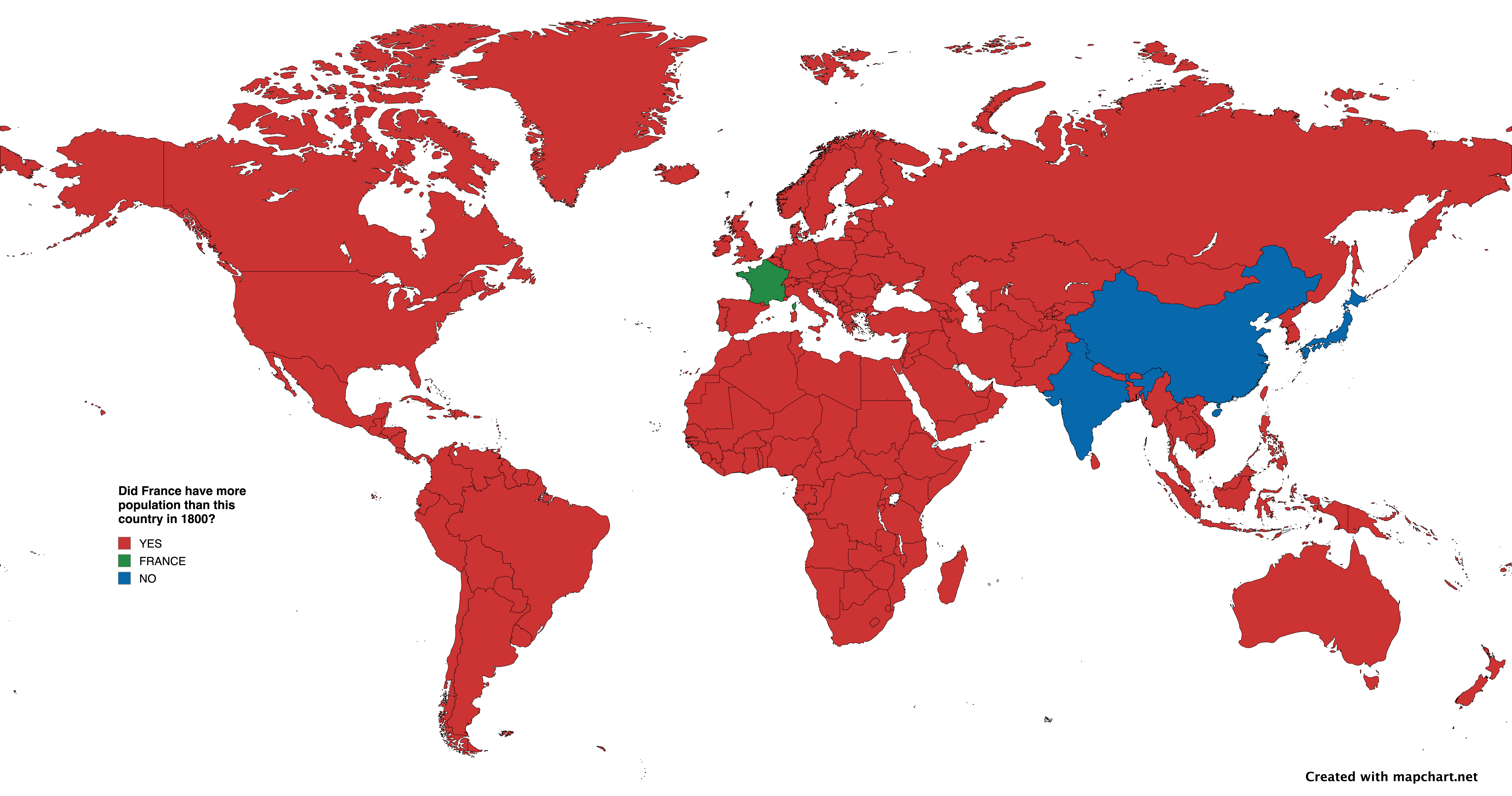

![[OC] Did France have more people than your country in 1800?](https://www.byteseu.com/wp-content/uploads/2025/02/cevf6blcxkie1-1536x809.png "[OC] Did France have more people than your country in 1800?")
16 Comments
Source: [https://en.wikipedia.org/wiki/List_of_countries_by_population_in_1800](https://en.wikipedia.org/wiki/List_of_countries_by_population_in_1800)
Tool: [Mapchart.net](http://Mapchart.net)
I’d never would’ve thought that the third option to yes/no will be France
Your map is off according to the data you cited. England and the “Holy Roman Empire” had a higher population than France in 1800 and your map claims otherwise.
A lot of those countries in central and east europe didn’t even exist. a lot of them were mixed between ottoman and austria monarchy.
This map is incorrect about Russia, which had a population of about 32 – 35 million, more than France (29 – 30 million).
https://worldpopulationreview.com/country-rankings/population-by-country-in-1800
https://www.ined.fr/fichier/s_rubrique/19155/pesa487.en.pdf
This map is wrong. I see at least one mistake: Russia (No, I don’t support Putin, just tell the truth). I bet, it has other mistakes as well.
The UK had to invent mechanised agriculture because it don’t want France to win anything.
This is a weirdly convoluted way to say “France was the 4th most populous country in 1800.” You know the phrase, ‘This could’ve been an email’?
“Did France have more people than your country in 1800?”
“FRANCE”
A better question would be “Did your country have a proper census program in 1800?”
This makes zero sense as it depicts modern borders, my country (Canada) didn’t exist in 1800 along with many others.
Even if you take the view that a Westphalian-style state is synonymous with our modern usage of the word “country”, your map does not show the extant polities of 1800 with relevant borders.
This would make more sense with a map representing political borders at the time.
Why are you counting India as one state?
It should be Marathas, Sikhs etc separately.
Maybe one or two of them had more people but not all
/r/dataisbeautiful
Rule 1:
A post must be (or contain) a qualifying data visualization.
From qualifying data visualization rules:
***In addition, binary TRUE/FALSE maps are not enough to communicate something that a table couldn’t. If your map doesn’t apply, you can always post to /r/mapporn.***
A lot of these countries didn’t exist in 1800.