[OC] I measured the specs of every Idaho high school home baseball field. Here is Part One of what are, in my opinion, some of the weirdest fields you can play on in an Idaho high school baseball game.
Posted by dvd5671

![[OC] I measured the specs of every Idaho high school home baseball field. Here is Part One of what are, in my opinion, some of the weirdest fields you can play on in an Idaho high school baseball game.](https://www.byteseu.com/wp-content/uploads/2025/02/iccxqbzcwwle1-1024x1024.png "[OC] I measured the specs of every Idaho high school home baseball field. Here is Part One of what are, in my opinion, some of the weirdest fields you can play on in an Idaho high school baseball game.")
[OC] I measured the specs of every Idaho high school home baseball field. Here is Part One of what are, in my opinion, some of the weirdest fields you can play on in an Idaho high school baseball game.
Posted by dvd5671
5 Comments
Hello everyone,
I am currently plotting, measuring, and visualizing every single high school baseball field in the United States. I currently have all of the data for Alaska, Colorado, Connecticut, Delaware, Idaho, Maine, Massachusetts, Nevada, North Dakota, Nebraska, New Hampshire, New Jersey, New Mexico, Ohio, Utah, Hawaii, Rhode Island, Vermont, and West Virginia (working on Maryland, South Carolina and Pennsylvania).
[Here’s the link to a Google doc I made with the links to all previous states and infographics (now including BlueSky links for some), along with my store where you can buy posters for certain states.](https://docs.google.com/document/d/1HlGoy2qUAue79Qx7VQNWOzjouPO17Jt4NJVhP5PQT-s/edit?usp=sharing)
**Sources:** Idaho High School Activities Association, Google Maps imagery, MaxPreps
**Tools:** Google Maps, Google Earth, Illustrator, Photoshop, Google Sheets
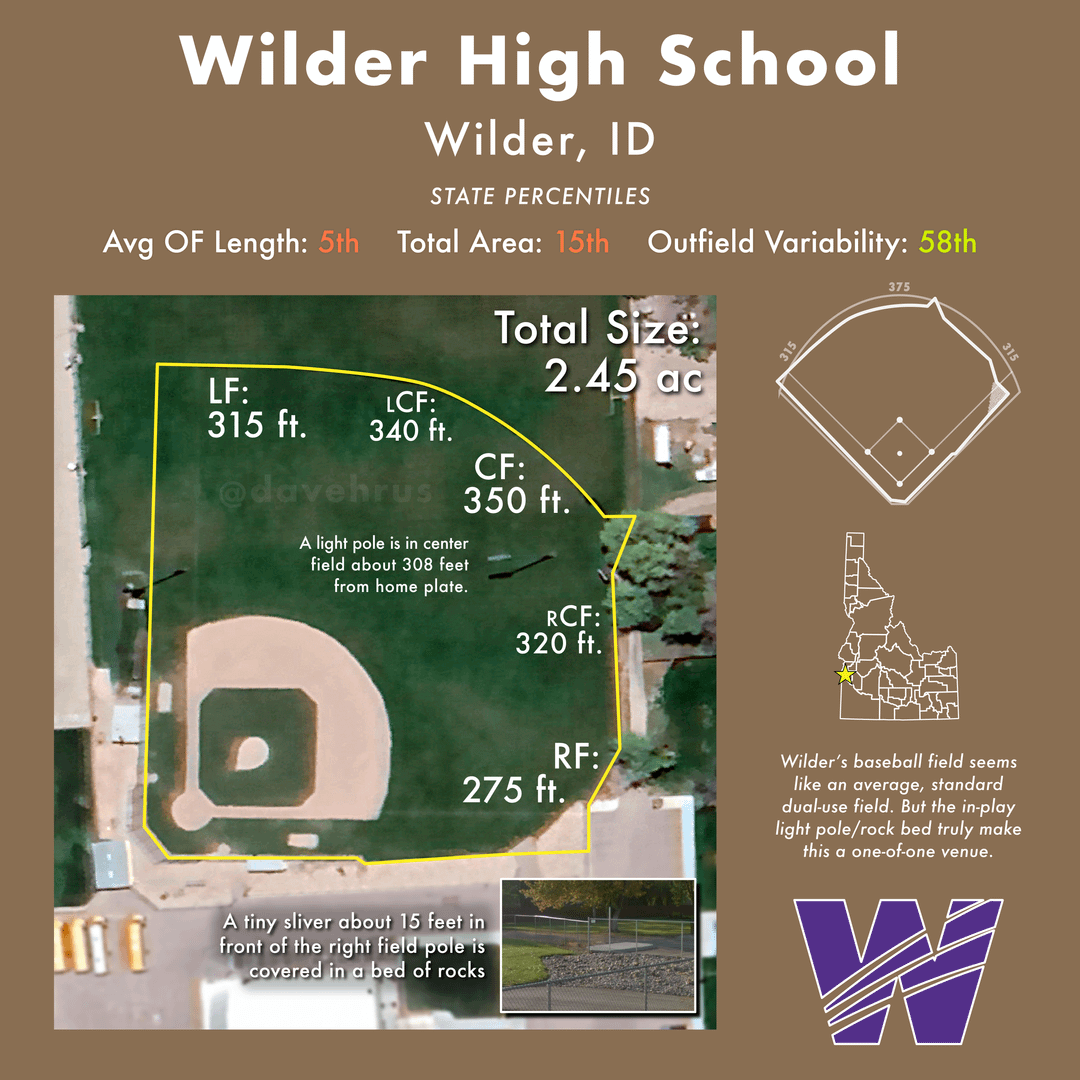
Why couldn’t Wilder go straight across with the fence? Also why tf do they have a light pole in the middle of center field? Lol
I love high school logos that are just recolored pro team logos
The light pole installed *after* the field was built is incredibly funny. Who signed off on that?!
I love these posts. Keep em coming!